Chapter 2
New Land
The first day of the New Year (January 1, 1915) was cloudy, with a gentle northerly breeze and occasional snow-squalls. The condition of the pack improved in the evening, and after 8 p.m. we forged ahead rapidly through brittle young ice, easily broken by the ship. A few hours later a moderate gale came up from the east, with continuous snow. After 4 a.m. on the 2nd we got into thick old pack-ice, showing signs of heavy pressure. It was much hummocked, but large areas of open water and long leads to the south-west continued until noon. The position then was lat. 69° 49´ S., long. 15° 42´ W., and the run for the twenty-four hours had been 124 miles S. 3° W. This was cheering.
The first day of the New Year (January 1, 1915) was cloudy, with a gentle northerly breeze and occasional snow squalls. The pack ice improved in the evening. After 8 p.m., we moved ahead rapidly through brittle young ice that the ship broke easily. A few hours later, a moderate gale came from the east, bringing continuous snow. After 4 a.m. on the 2nd, we entered thick, old pack ice that showed signs of heavy pressure. The ice was piled into ridges, but large areas of open water and long channels to the southwest continued until noon. Our position then was latitude 69° 49´ S., longitude 15° 42´ W. In the previous twenty-four hours, we had traveled 124 miles on a course 3° west of south. This was encouraging.
The heavy pack blocked the way south after midday. It would have been almost impossible to have pushed the ship into the ice, and in any case the gale would have made such a proceeding highly dangerous. So we dodged along to the west and north, looking for a suitable opening towards the south. The good run had given me hope of sighting the land on the following day, and the delay was annoying. I was growing anxious to reach land on account of the dogs, which had not been able to get exercise for four weeks, and were becoming run down. We passed at least two hundred bergs during the day, and we noticed also large masses of hummocky bay-ice and ice-foot. One floe of bay-ice had black earth upon it, apparently basaltic in origin, and there was a large berg with a broad band of yellowish brown right through it. The stain may have been volcanic dust. Many of the bergs had quaint shapes. There was one that exactly resembled a large two-funnel liner, complete in silhouette except for smoke. Later in the day we found an opening in the pack and made 9 miles to the south-west, but at 2 a.m. on January 3 the lead ended in hummocky ice, impossible to penetrate. A moderate easterly gale had come up with snow-squalls, and we could not get a clear view in any direction. The hummocky ice did not offer a suitable anchorage for the ship, and we were compelled to dodge up and down for ten hours before we were able to make fast to a small floe under the lee of a berg 120 ft. high. The berg broke the wind and saved us drifting fast to leeward. The position was lat. 69° 59´ S., long. 17° 31´ W. We made a move again at 7 p.m., when we took in the ice-anchor and proceeded south, and at 10 p.m. we passed a small berg that the ship had nearly touched twelve hours previously. Obviously we were not making much headway. Several of the bergs passed during this day were of solid blue ice, indicating true glacier origin.
After midday, the dense pack ice blocked our way south. It would have been almost impossible to push the ship into the ice. In any case, the gale would have made the attempt highly dangerous. So we maneuvered west and north, looking for a suitable opening to the south. Our good progress had given me hope of sighting land the next day, and the delay was annoying. I was growing anxious to reach land because of the dogs. They had been unable to exercise for four weeks and were becoming run down. We passed at least two hundred icebergs during the day. We also noticed large masses of ridged bay ice and ice-foot. One floe of bay ice had black earth on it, apparently basaltic in origin. A large iceberg had a broad yellowish-brown band running right through it. The stain may have been volcanic dust. Many of the icebergs had curious shapes. One looked exactly like a large ocean liner with two funnels, complete in silhouette except for the smoke. Later that day, we found an opening in the pack ice and traveled 9 miles southwest. But at 2 a.m. on January 3, the open channel ended in ridged ice that was impossible to penetrate. A moderate easterly gale had come up, bringing snow squalls, and we could not see clearly in any direction. The ridged ice offered no suitable anchorage for the ship. So we had to maneuver up and down for ten hours before we could tie up to a small floe. The floe lay sheltered from the wind by an iceberg 120 feet high. The iceberg broke the wind and kept us from drifting quickly away with it. Our position was latitude 69° 59´ S., longitude 17° 31´ W. We moved again at 7 p.m., taking in the ice anchor and heading south. At 10 p.m. we passed a small iceberg that the ship had nearly touched twelve hours earlier. Clearly, we were not making much progress. Several of the icebergs we passed that day were made of solid blue ice, showing that they came from glaciers.
By midnight of the 3rd we had made 11 miles to the south, and then came to a full stop in weather so thick with snow that we could not learn if the leads and lanes were worth entering. The ice was hummocky, but, fortunately, the gale was decreasing, and after we had scanned all the leads and pools within our reach we turned back to the north-east. Two sperm and two large blue whales were sighted, the first we had seen for 260 miles. We saw also petrels, numerous adelies, emperors, crab-eaters, and sea-leopards. The clearer weather of the morning showed us that the pack was solid and impassable from the south-east to the south-west, and at 10 a.m. on the 4th we again passed within five yards of the small berg that we had passed twice on the previous day. We had been steaming and dodging about over an area of twenty square miles for fifty hours, trying to find an opening to the south, south-east, or south-west, but all the leads ran north, north-east, or north-west. It was as though the spirits of the Antarctic were pointing us to the backward track—the track we were determined not to follow. Our desire was to make easting as well as southing so as to reach the land, if possible, east of Ross’s farthest South and well east of Coats’ Land. This was more important as the prevailing winds appeared to be to easterly, and every mile of easting would count. In the afternoon we went west in some open water, and by 4 p.m. we were making west-south-west with more water opening up ahead. The sun was shining brightly, over three degrees high at midnight, and we were able to maintain this direction in fine weather till the following noon. The position then was lat. 70° 28´ S., long. 20° 16´ W., and the run had been 62 miles S. 62° W. At 8 a.m. there had been open water from north round by west to south-west, but impenetrable pack to the south and east. At 3 p.m. the way to the south-west and west-north-west was absolutely blocked, and as we experienced a set to the west, I did not feel justified in burning more of the reduced stock of coal to go west or north. I took the ship back over our course for four miles, to a point where some looser pack gave faint promise of a way through; but, after battling for three hours with very heavy hummocked ice and making four miles to the south, we were brought up by huge blocks and floes of very old pack. Further effort seemed useless at that time, and I gave the order to bank fires after we had moored the Endurance to a solid floe. The weather was clear, and some enthusiastic football-players had a game on the floe until, about midnight, Worsley dropped through a hole in rotten ice while retrieving the ball. He had to be retrieved himself.
By midnight on the 3rd, we had traveled 11 miles south. Then we came to a complete stop. The snow was so thick that we could not tell whether the leads and lanes were worth entering. The ice was rough and piled into hummocks, but fortunately the gale was easing. After examining all the leads and pools within reach, we turned back northeast. We sighted two sperm whales and two large blue whales, the first whales we had seen for 260 miles. We also saw petrels, numerous adelies, emperors, crab-eaters, and sea-leopards. Clearer weather that morning showed us that the pack ice was solid and impassable from southeast to southwest. At 10 a.m. on the 4th, we again passed within five yards of the small berg we had passed twice the previous day. For fifty hours, we had steamed and maneuvered over an area of twenty square miles. We were trying to find an opening to the south, southeast, or southwest, but all the leads ran north, northeast, or northwest. It was as though the spirits of the Antarctic were pointing us back the way we had come. That was the route we were determined not to follow. We wanted to travel east as well as south. That way, we hoped to reach land east of Ross’s farthest South and well east of Coats’ Land, if possible. This was especially important because the prevailing winds appeared to be easterly, and every mile east would count. That afternoon we went west through some open water. By 4 p.m. we were heading west-southwest, with more open water ahead. The sun shone brightly and was more than three degrees above the horizon at midnight. In the fine weather, we were able to hold this course until noon the next day. Our position then was lat. 70° 28´ S., long. 20° 16´ W., and we had traveled 62 miles on a course S. 62° W. At 8 a.m. there had been open water from the north, around by the west, to the southwest. But the pack ice to the south and east was impenetrable. By 3 p.m. the routes southwest and west-northwest were completely blocked. A current was carrying us west, and I did not feel justified in burning more of our reduced coal supply to go west or north. I took the ship back four miles along our course, to where some looser pack ice offered a faint hope of a passage. We battled for three hours through very heavy hummocked ice and made four miles south. Then huge blocks and floes of very old pack ice stopped us. Further effort seemed useless for the time being. After we moored the Endurance to a solid floe, I gave the order to bank the fires. The weather was clear, and some enthusiastic football players had a game on the floe. Around midnight, Worsley fell through a hole in rotten ice while retrieving the ball. He had to be retrieved himself.
Solid pack still barred the way to the south on the following morning (January 6). There was some open water north of the floe, but as the day was calm and I did not wish to use coal in a possibly vain search for an opening to the southward, I kept the ship moored to the floe. This pause in good weather gave an opportunity to exercise the dogs, which were taken on to the floe by the men in charge of them. The excitement of the animals was intense. Several managed to get into the water, and the muzzles they were wearing did not prevent some hot fights. Two dogs which had contrived to slip their muzzles fought themselves into an icy pool and were hauled out still locked in a grapple. However, men and dogs enjoyed the exercise. A sounding gave a depth of 2400 fathoms, with a blue mud bottom. The wind freshened from the west early the next morning, and we started to skirt the northern edge of the solid pack in an easterly direction under sail. We had cleared the close pack by noon, but the outlook to the south gave small promise of useful progress, and I was anxious now to make easting. We went north-east under sail, and after making thirty-nine miles passed a peculiar berg that we had been abreast of sixty hours earlier. Killer-whales were becoming active around us, and I had to exercise caution in allowing any one to leave the ship. These beasts have a habit of locating a resting seal by looking over the edge of a floe and then striking through the ice from below in search of a meal; they would not distinguish between seal and man.
Solid pack ice still blocked the way south the following morning (January 6). There was some open water north of the floe. But the day was calm, and I did not want to use coal searching for an opening south that might not exist. So I kept the ship moored to the floe. The pause in good weather gave us a chance to exercise the dogs. The men in charge of the dogs took them onto the floe. The animals were intensely excited. Several managed to get into the water, and their muzzles did not prevent some fierce fights. Two dogs managed to slip off their muzzles and fought their way into an icy pool. They were hauled out still locked together. However, both men and dogs enjoyed the exercise. A sounding showed a depth of 2,400 fathoms, with blue mud on the bottom. Early the next morning, the wind grew stronger from the west. We set sail eastward along the northern edge of the solid pack ice. By noon we had cleared the closely packed ice, but there was little hope of making useful progress south. I was now anxious to make progress eastward. We sailed northeast, and after covering thirty-nine miles we passed a peculiar iceberg. We had been alongside it sixty hours earlier. Killer whales were becoming active around us, so I had to be careful about letting anyone leave the ship. These animals have a habit of looking over the edge of a floe to locate a resting seal. They then strike through the ice from below to find a meal. They would not distinguish between a seal and a person.
The noon position on January 8 was lat. 70° 0´ S., long. 19° 09´ W. We had made 66 miles in a north-easterly direction during the preceding twenty-four hours. The course during the afternoon was east-south-east through loose pack and open water, with deep hummocky floes to the south. Several leads to the south came in view, but we held on the easterly course. The floes were becoming looser, and there were indications of open water ahead. The ship passed not fewer than five hundred bergs that day, some of them very large. A dark water-sky extended from east to south-south-east on the following morning, and the Endurance, working through loose pack at half speed, reached open water just before noon. A rampart berg 150 ft. high and a quarter of a mile long lay at the edge of the loose pack, and we sailed over a projecting foot of this berg into rolling ocean, stretching to the horizon. The sea extended from a little to the west of south, round by east to north-north-east, and its welcome promise was supported by a deep water-sky to the south. I laid a course south by east in an endeavour to get south and east of Ross’s farthest south (lat. 71° 30´ S.).
At noon on January 8, our position was lat. 70° 0´ S., long. 19° 09´ W. We had traveled 66 miles north-east during the previous twenty-four hours. That afternoon, we headed east-south-east through loose pack ice and open water, with deep, hummocky floes to the south. Several channels through the ice appeared to the south, but we kept heading east. The floes were becoming more widely separated, and there were signs of open water ahead. The ship passed at least five hundred icebergs that day, some of them very large. The following morning, a dark water-sky stretched from east to south-south-east. The Endurance worked through loose pack ice at half speed and reached open water just before noon. A rampart iceberg, 150 feet high and a quarter of a mile long, lay at the edge of the pack ice. We sailed over its projecting foot into rolling ocean that stretched to the horizon. The open sea extended from just west of south, around by east to north-north-east. A deep water-sky to the south added to the welcome promise of open water. I set a course south by east, hoping to get south and east of Ross’s farthest south (lat. 71° 30´ S.).
We kept the open water for a hundred miles, passing many bergs but encountering no pack. Two very large whales, probably blue whales, came up close to the ship, and we saw spouts in all directions. Open water inside the pack in that latitude might have the appeal of sanctuary to the whales, which are harried by man farther north. The run southward in blue water, with a path clear ahead and the miles falling away behind us, was a joyful experience after the long struggle through the ice-lanes. But, like other good things, our spell of free movement had to end. The Endurance encountered the ice again at 1 a.m. on the 10th. Loose pack stretched to east and south, with open water to the west and a good watersky. It consisted partly of heavy hummocky ice showing evidence of great pressure, but contained also many thick, flat floes evidently formed in some sheltered bay and never subjected to pressure or to much motion. The swirl of the ship’s wash brought diatomaceous scum from the sides of this ice. The water became thick with diatoms at 9 a.m., and I ordered a cast to be made. No bottom was found at 210 fathoms. The Endurance continued to advance southward through loose pack that morning. We saw the spouts of numerous whales and noticed some hundreds of crab-eaters lying on the floes. White-rumped terns, Antarctic petrels and snow petrels were numerous, and there was a colony of adelies on a low berg. A few killer-whales, with their characteristic high dorsal fin, also came in view. The noon position was lat. 72° 02´ S., long. 16° 07´ W., and the run for the twenty-four hours had been 136 miles S. 6° E.
We stayed in open water for a hundred miles, passing many icebergs but encountering no pack ice. Two very large whales, probably blue whales, surfaced close to the ship, and we saw spouts in all directions. The open water inside the pack at that latitude might have been a sanctuary for whales hunted by humans farther north. Our southward journey through blue water was joyful after the long struggle through the ice-lanes. The path ahead was clear, and the miles fell away behind us. But, like other good things, our spell of free movement had to end. The Endurance encountered ice again at 1 a.m. on the 10th. Loose pack ice stretched to the east and south. There was open water to the west and a clear sign of open water in the sky. Some of the pack consisted of heavy, hummocky ice showing signs of great pressure. But it also contained many thick, flat floes. These had evidently formed in a sheltered bay and had never been subjected to pressure or much movement. The swirl of the ship’s wake brought scum made of diatoms from the sides of the ice. At 9 a.m., the water became thick with diatoms, and I ordered a depth sounding. We found no bottom at 210 fathoms. The Endurance continued south through loose pack ice that morning. We saw the spouts of numerous whales and noticed several hundred crab-eater seals lying on the floes. White-rumped terns, Antarctic petrels and snow petrels were numerous, and a colony of adelies lived on a low iceberg. A few killer whales also came into view, with their characteristic high dorsal fins. Our position at noon was lat. 72° 02´ S., long. 16° 07´ W. We had traveled 136 miles S. 6° E. in twenty-four hours.
We were now in the vicinity of the land discovered by Dr. W. S. Bruce, leader of the Scotia Expedition, in 1904, and named by him Coats’ Land. Dr. Bruce encountered an ice-barrier in lat. 72° 18´ S., long. 10° W., stretching from north-east to south-west. He followed the barrier-edge to the south-west for 150 miles and reached lat. 74° 1´ S., long. 22° W. He saw no naked rock, but his description of rising slopes of snow and ice, with shoaling water off the barrier-wall, indicated clearly the presence of land. It was up those slopes, at a point as far south as possible, that I planned to begin the march across the Antarctic continent. All hands were watching now for the coast described by Dr. Bruce, and at 5 p.m. the look-out reported an appearance of land to the south-south-east. We could see a gentle snow-slope rising to a height of about one thousand feet. It seemed to be an island or a peninsula with a sound on its south side, and the position of its most northerly point was about 72° 34´ S., 16° 40´ W. The Endurance was passing through heavy loose pack, and shortly before midnight she broke into a lead of open sea along a barrier-edge. A sounding within one cable’s length of the barrier-edge gave no bottom with 210 fathoms of line. The barrier was 70 ft. high, with cliffs of about 40 ft. The Scotia must have passed this point when pushing to Bruce’s farthest south on March 6, 1904, and I knew from the narrative of that voyage, as well as from our own observation, that the coast trended away to the south-west. The lead of open water continued along the barrier-edge, and we pushed forward without delay.
We were now near the land discovered in 1904 by Dr. W. S. Bruce, leader of the Scotia Expedition. He had named it Coats’ Land. Dr. Bruce encountered an ice barrier at lat. 72° 18´ S., long. 10° W. It stretched from northeast to southwest. He followed the barrier’s edge southwest for 150 miles, reaching lat. 74° 1´ S., long. 22° W. He saw no exposed rock. But he described rising slopes of snow and ice, with water becoming shallower near the barrier wall. This clearly indicated the presence of land. I planned to begin the march across the Antarctic continent up those slopes, at a point as far south as possible. All hands were now watching for the coast described by Dr. Bruce. At 5 p.m., the lookout reported what appeared to be land to the south-southeast. We could see a gentle snow slope rising to about one thousand feet. It seemed to be an island or a peninsula with a channel on its south side. Its northernmost point was at about 72° 34´ S., 16° 40´ W. The Endurance was passing through heavy, loose pack ice. Shortly before midnight, she broke through into a stretch of open water along the barrier’s edge. Less than a cable’s length from the barrier, we lowered 210 fathoms of sounding line without reaching bottom. The barrier was 70 feet high, with cliffs of about 40 feet. The Scotia must have passed this point on March 6, 1904, when Bruce pushed as far south as he could. From the account of that voyage, as well as our own observations, I knew the coast turned southwest. The stretch of open water continued along the barrier’s edge, and we pushed forward without delay.
An easterly breeze brought cloud and falls of snow during the morning of January 11. The barrier trended south-west by south, and we skirted it for fifty miles until 11 am. The cliffs in the morning were 20 ft. high, and by noon they had increased to 110 and 115 ft. The brow apparently rose 20 to 30 ft. higher. We were forced away from the barrier once for three hours by a line of very heavy pack-ice. Otherwise there was open water along the edge, with high loose pack to the west and north-west. We noticed a seal bobbing up and down in an apparent effort to swallow a long silvery fish that projected at least eighteen inches from its mouth. The noon position was lat. 73° 13´ S., long. 20° 43´ W., and a sounding then gave 155 fathoms at a distance of a mile from the barrier. The bottom consisted of large igneous pebbles. The weather then became thick, and I held away to the westward, where the sky had given indications of open water, until 7 p.m., when we laid the ship alongside a floe in loose pack. Heavy snow was falling, and I was anxious lest the westerly wind should bring the pack hard against the coast and jam the ship. The Nimrod had a narrow escape from a misadventure of this kind in the Ross Sea early in 1908.
An easterly breeze brought clouds and snow during the morning of January 11. The barrier ran south-west by south, and we followed its edge for fifty miles until 11 a.m. In the morning, the cliffs were 20 feet high. By noon, they had risen to between 110 and 115 feet. The brow apparently rose another 20 to 30 feet. A line of very heavy pack ice forced us away from the barrier for three hours. Otherwise, there was open water along the edge, with high, loose pack ice to the west and north-west. We noticed a seal bobbing up and down, apparently trying to swallow a long, silvery fish. The fish projected at least eighteen inches from its mouth. At noon, our position was lat. 73° 13´ S., long. 20° 43´ W. A sounding taken then, a mile from the barrier, showed a depth of 155 fathoms. The bottom consisted of large igneous pebbles. The weather then became thick, and I headed westward, where the sky had shown signs of open water. At 7 p.m., we brought the ship alongside a floe in loose pack ice. Heavy snow was falling, and I feared that the westerly wind would drive the pack ice hard against the coast and trap the ship. The Nimrod had narrowly escaped a similar mishap in the Ross Sea early in 1908.
We made a start again at 5 a.m. the next morning (January 12) in overcast weather with mist and snow-showers, and four hours later broke through loose pack-ice into open water. The view was obscured, but we proceeded to the south-east and had gained 24 miles by noon, when three soundings in lat. 74° 4´ S., long. 22° 48´ W. gave 95, 128, and 103 fathoms, with a bottom of sand, pebbles, and mud. Clark got a good haul of biological specimens in the dredge. The Endurance was now close to what appeared to be the barrier, with a heavy pack-ice foot containing numerous bergs frozen in and possibly aground. The solid ice turned away towards the north-west, and we followed the edge for 48 miles N. 60° W. to clear it.
We set off again at 5 a.m. the next morning (January 12). The weather was overcast, with mist and snow showers. Four hours later, we broke through loose pack ice into open water. Visibility was poor, but we continued southeast and had covered 24 miles by noon. At lat. 74° 4´ S., long. 22° 48´ W., three depth measurements gave 95, 128, and 103 fathoms. The seabed was sand, pebbles, and mud. Clark collected a good haul of biological specimens with the dredge. The Endurance was now close to what appeared to be the barrier. Along its edge was a thick mass of pack ice containing numerous icebergs. The icebergs were frozen into the pack and possibly resting on the seabed. The solid ice turned away toward the northwest, and we followed its edge for 48 miles N. 60° W. to get clear of it.
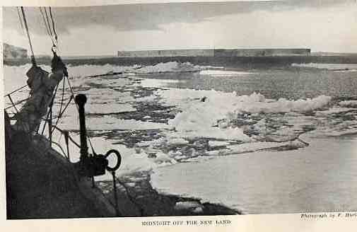
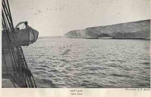
Now we were beyond the point reached by the Scotia, and the land underlying the ice-sheet we were skirting was new. The northerly trend was unexpected, and I began to suspect that we were really rounding a huge ice-tongue attached to the true barrier-edge and extending northward. Events confirmed this suspicion. We skirted the pack all night, steering north-west; then went west by north till 4 a.m. and round to south-west. The course at 8 a.m. on the 13th was south-south-west. The barrier at midnight was low and distant, and at 8 a.m. there was merely a narrow ice-foot about two hundred yards across separating it from the open water. By noon there was only an occasional shelf of ice-foot. The barrier in one place came with an easy sweep to the sea. We could have landed stores there without difficulty. We made a sounding 400 ft. off the barrier but got no bottom at 676 fathoms. At 4 p.m., still following the barrier to the south-west, we reached a corner and found it receding abruptly to the south-east. Our way was blocked by very heavy pack, and after spending two hours in a vain search for an opening, we moored the Endurance to a floe and banked fires. During that day we passed two schools of seals, swimming fast to the north-west and north-north-east. The animals swam in close order, rising and blowing like porpoises, and we wondered if there was any significance in their journey northward at that time of the year. Several young emperor penguins had been captured and brought aboard on the previous day. Two of them were still alive when the Endurance was brought alongside the floe. They promptly hopped on to the ice, turned round, bowed gracefully three times, and retired to the far side of the floe. There is something curiously human about the manners and movements of these birds. I was concerned about the dogs. They were losing condition and some of them appeared to be ailing. One dog had to be shot on the 12th. We did not move the ship on the 14th. A breeze came from the east in the evening, and under its influence the pack began to work off shore. Before midnight the close ice that had barred our way had opened and left a lane along the foot of the barrier. I decided to wait for the morning, not wishing to risk getting caught between the barrier and the pack in the event of the wind changing. A sounding gave 1357 fathoms, with a bottom of glacial mud. The noon observation showed the position to be lat. 74° 09´ S., long. 27° 16´ W. We cast off at 6 a.m. on the 15th in hazy weather with a north-easterly breeze, and proceeded along the barrier in open water. The course was south-east for sixteen miles, then south-south-east. We now had solid pack to windward, and at 3 p.m. we passed a bight probably ten miles deep and running to the north-east. A similar bight appeared at 6 p.m. These deep cuts strengthened the impression we had already formed that for several days we had been rounding a great mass of ice, at least fifty miles across, stretching out from the coast and possibly destined to float away at some time in the future. The soundings—roughly, 200 fathoms at the landward side and 1300 fathoms at the seaward side—suggested that this mighty projection was afloat. Seals were plentiful. We saw large numbers on the pack and several on low parts of the barrier, where the slope was easy. The ship passed through large schools of seals swimming from the barrier to the pack off shore. The animals were splashing and blowing around the Endurance, and Hurley made a record of this unusual sight with the kinematograph-camera.
We were now beyond the point reached by the Scotia, and the land beneath the ice sheet we were following was unknown. The ice sheet’s northward course was unexpected. I began to suspect that we were rounding a huge tongue of ice attached to the main barrier’s edge and extending northward. Events confirmed this suspicion. We followed the pack ice all night, steering northwest. Then we headed west by north until 4 a.m. and turned southwest. At 8 a.m. on the 13th, our course was south-southwest. At midnight, the barrier was low and distant. By 8 a.m., only a narrow strip of ice-foot, about two hundred yards across, separated the barrier from open water. By noon, only occasional shelves of ice-foot remained. In one place, the barrier sloped gently down to the sea. We could have landed stores there without difficulty. We measured the depth 400 feet from the barrier but found no bottom at 676 fathoms. At 4 p.m., still following the barrier southwest, we reached a corner. There we found the barrier turning sharply away to the southeast. Very heavy pack ice blocked our way. After spending two hours searching in vain for an opening, we moored the Endurance to a floe and banked the fires. That day we passed two schools of seals swimming fast, one to the northwest and the other to the north-northeast. The seals swam close together, rising and blowing like porpoises. We wondered whether there was any significance in their journey northward at that time of year. Several young emperor penguins had been captured and brought aboard the previous day. Two were still alive when the Endurance came alongside the floe. They promptly hopped onto the ice, turned around, bowed gracefully three times, and withdrew to the far side of the floe. There is something curiously human about these birds’ manners and movements. I was concerned about the dogs. They were losing condition, and some appeared to be ill. One dog had to be shot on the 12th. We did not move the ship on the 14th. A breeze came from the east that evening, and the pack ice began to move offshore. Before midnight, the tightly packed ice that had blocked our way opened up, leaving a channel along the foot of the barrier. I decided to wait until morning. I did not want to risk getting caught between the barrier and the pack if the wind changed. A depth measurement showed 1357 fathoms, with glacial mud on the bottom. The noon observation showed our position as lat. 74° 09´ S., long. 27° 16´ W. We cast off at 6 a.m. on the 15th in hazy weather, with a northeasterly breeze, and followed the barrier through open water. Our course was southeast for sixteen miles, then south-southeast. We now had solid pack ice on the windward side. At 3 p.m. we passed a bight, or inlet, probably ten miles deep, running northeast. A similar bight appeared at 6 p.m. These deep cuts strengthened the impression we had already formed. For several days, we had been rounding a great mass of ice at least fifty miles across. It stretched out from the coast and might float away sometime in the future. Depth measurements suggested that this mighty projection was afloat. The water was roughly 200 fathoms deep on the landward side and 1300 fathoms deep on the seaward side. Seals were plentiful. We saw large numbers on the pack ice and several on low parts of the barrier, where the slope was gentle. The ship passed through large schools of seals swimming from the barrier to the pack ice offshore. The animals splashed and blew around the Endurance, and Hurley recorded this unusual sight with the kinematograph-camera.
The barrier now stretched to the south-west again. Sail was set to a fresh easterly breeze, but at 7 p.m. it had to be furled, the Endurance being held up by pack-ice against the barrier for an hour. We took advantage of the pause to sound and got 268 fathoms with glacial mud and pebbles. Then a small lane appeared ahead. We pushed through at full speed, and by 8.30 p.m. the Endurance was moving southward with sails set in a fine expanse of open water. We continued to skirt the barrier in clear weather. I was watching for possible landing-places, though as a matter of fact I had no intention of landing north of Vahsel Bay, in Luitpold Land, except under pressure of necessity. Every mile gained towards the south meant a mile less sledging when the time came for the overland journey.
The barrier now stretched southwest again. We set sail in a fresh easterly breeze, but at 7 p.m. we had to take the sails down. Pack ice held the Endurance against the barrier for an hour. During the pause, we measured the depth and found 268 fathoms, with glacial mud and pebbles on the bottom. Then a small opening appeared ahead. We pushed through at full speed. By 8:30 p.m., the Endurance was sailing south across a broad stretch of open water. We continued along the edge of the barrier in clear weather. I watched for possible landing places, although I had no intention of landing north of Vahsel Bay in Luitpold Land unless necessary. Every mile we gained southward meant one less mile of sledging when the time came for the overland journey.
Shortly before midnight on the 15th we came abreast of the northern edge of a great glacier or overflow from the inland ice, projecting beyond the barrier into the sea. It was 400 or 500 ft. high, and at its edge was a large mass of thick bay-ice. The bay formed by the northern edge of this glacier would have made an excellent landing-place. A flat ice-foot nearly three feet above sea-level looked like a natural quay. From this ice-foot a snow-slope rose to the top of the barrier. The bay was protected from the south-easterly wind and was open only to the northerly wind, which is rare in those latitudes. A sounding gave 80 fathoms, indicating that the glacier was aground. I named the place Glacier Bay, and had reason later to remember it with regret.
Shortly before midnight on the 15th, we came alongside the northern edge of a great glacier. It was an overflow of inland ice that projected beyond the barrier into the sea. The glacier was 400 or 500 feet high, with a large mass of thick bay ice at its edge. The bay formed by the glacier’s northern edge would have made an excellent landing place. A flat shelf of ice, nearly three feet above sea level, looked like a natural quay. From this shelf, a snow slope rose to the top of the barrier. The bay was sheltered from the southeasterly wind and open only to the northerly wind, which is rare in those latitudes. A depth measurement gave 80 fathoms, indicating that the glacier rested on the sea floor. I named the place Glacier Bay, and later had reason to remember it with regret.
The Endurance steamed along the front of this ice-flow for about seventeen miles. The glacier showed huge crevasses and high pressure ridges, and appeared to run back to ice-covered slopes or hills 1000 or 2000 ft. high. Some bays in its front were filled with smooth ice, dotted with seals and penguins. At 4 a.m. on the 16th we reached the edge of another huge glacial overflow from the ice-sheet. The ice appeared to be coming over low hills and was heavily broken. The cliff-face was 250 to 350 ft. high, and the ice surface two miles inland was probably 2000 ft. high. The cliff-front showed a tide-mark of about 6 ft., proving that it was not afloat. We steamed along the front of this tremendous glacier for 40 miles and then, at 8.30 a.m., we were held up by solid pack-ice, which appeared to be held by stranded bergs. The depth, two cables off the barrier-cliff, was 134 fathoms. No further advance was possible that day, but the noon observation, which gave the position as lat. 76° 27´ S. long. 28° 51´ W., showed that we had gained 124 miles to the south-west during the preceding twenty-four hours. The afternoon was not without incident. The bergs in the neighbourhood were very large, several being over 200 ft. high, and some of them were firmly aground, showing tidemarks. A barrier-berg bearing north-west appeared to be about 25 miles long. We pushed the ship against a small banded berg, from which Wordie secured several large lumps of biotite granite. While the Endurance was being held slow ahead against the berg a loud crack was heard, and the geologist had to scramble aboard at once. The bands on this berg were particularly well defined; they were due to morainic action in the parent glacier. Later in the day the easterly wind increased to a gale. Fragments of floe drifted past at about two knots, and the pack to leeward began to break up fast. A low berg of shallow draught drove down into the grinding pack and, smashing against two larger stranded bergs, pushed them off the bank. The three went away together pell-mell. We took shelter under the lee of a large stranded berg.
The Endurance steamed along the front of this ice flow for about seventeen miles. The glacier had huge crevasses and high pressure ridges. It appeared to extend back to ice-covered slopes or hills 1,000 or 2,000 feet high. Some bays along its front were filled with smooth ice, dotted with seals and penguins. At 4 a.m. on the 16th, we reached the edge of another huge glacial overflow from the ice sheet. The ice appeared to be coming over low hills and was heavily broken. The cliff face was 250 to 350 feet high. Two miles inland, the ice surface was probably 2,000 feet high. The cliff front had a tide mark about 6 feet high, proving that it was not afloat. We steamed along the front of this tremendous glacier for 40 miles. Then, at 8:30 a.m., solid pack ice stopped us. The pack ice appeared to be held in place by stranded icebergs. Two cables off the barrier cliff, the water was 134 fathoms deep. We could go no farther that day. But the noon observation placed us at lat. 76° 27´ S., long. 28° 51´ W. It showed that we had traveled 124 miles southwest during the previous twenty-four hours. The afternoon was not without incident. The nearby icebergs were very large, and several were over 200 feet high. Some were firmly aground and showed tide marks. A barrier iceberg to the northwest appeared to be about 25 miles long. We pushed the ship against a small banded iceberg. Wordie collected several large lumps of biotite granite from it. The Endurance was kept moving slowly forward against the iceberg. Then a loud crack was heard, and the geologist had to scramble aboard at once. The bands on this iceberg were particularly clear. They had been caused by morainic action in the parent glacier. Later in the day, the easterly wind strengthened to a gale. Fragments of ice floe drifted past at about two knots, and the pack ice downwind began to break up quickly. A low iceberg with a shallow draught was driven into the grinding pack. It smashed against two larger stranded icebergs and pushed them off the bank. The three went away together in a jumble. We took shelter on the sheltered side of a large stranded iceberg.
A blizzard from the east-north-east prevented us leaving the shelter of the berg on the following day (Sunday, January 17). The weather was clear, but the gale drove dense clouds of snow off the land and obscured the coast-line most of the time. “The land, seen when the air is clear, appears higher than we thought it yesterday; probably it rises to 3000 ft. above the head of the glacier. Caird Coast, as I have named it, connects Coats’ Land, discovered by Bruce in 1904, with Luitpold Land, discovered by Filchner in 1912. The northern part is similar in character to Coats’ Land. It is fronted by an undulating barrier, the van of a mighty ice-sheet that is being forced outward from the high interior of the Antarctic Continent and apparently is sweeping over low hills, plains, and shallow seas as the great Arctic ice-sheet once pressed over Northern Europe. The barrier surface, seen from the sea, is of a faint golden brown colour. It terminates usually in cliffs ranging from 10 to 300 ft. in height, but in a very few places sweeps down level with the sea. The cliffs are of dazzling whiteness, with wonderful blue shadows. Far inland higher slopes can be seen, appearing like dim blue or faint golden fleecy clouds. These distant slopes have increased in nearness and clearness as we have come to the south-west, while the barrier cliffs here are higher and apparently firmer. We are now close to the junction with Luitpold Land. At this southern end of the Caird Coast the ice-sheet, undulating over the hidden and imprisoned land, is bursting down a steep slope in tremendous glaciers, bristling with ridges and spikes of ice and seamed by thousands of crevasses. Along the whole length of the coast we have seen no bare land or rock. Not as much as a solitary nunatak has appeared to relieve the surface of ice and snow. But the upward sweep of the ice-slopes towards the horizon and the ridges, terraces, and crevasses that appear as the ice approaches the sea tell of the hills and valleys that lie below.”
A blizzard from the east-north-east prevented us from leaving the shelter of the berg the next day (Sunday, January 17). The weather was clear, but the gale blew dense clouds of snow off the land. Most of the time, the snow hid the coast. “The land, when the air is clear enough to see it, looks higher than we thought yesterday. It probably rises to 3,000 feet above the head of the glacier. Caird Coast, as I have named it, connects Coats’ Land, discovered by Bruce in 1904, with Luitpold Land, discovered by Filchner in 1912. The northern part is similar to Coats’ Land. An undulating ice barrier fronts the coast. It is the leading edge of a mighty ice sheet being forced outward from the high interior of the Antarctic Continent. The ice sheet appears to be sweeping over low hills, plains, and shallow seas. In the same way, the great Arctic ice sheet once pressed over Northern Europe. “Seen from the sea, the barrier’s surface is a faint golden brown. It usually ends in cliffs ranging from 10 to 300 feet high. In a very few places, however, it slopes down to sea level. The cliffs are dazzling white, with wonderful blue shadows. Far inland, higher slopes look like dim blue or faint golden fleecy clouds. These distant slopes have appeared closer and clearer as we have traveled south-west. The barrier cliffs here are also higher and apparently firmer. “We are now close to the junction with Luitpold Land. At this southern end of Caird Coast, the ice sheet undulates over the hidden, imprisoned land. It bursts down a steep slope in tremendous glaciers. These glaciers bristle with ridges and spikes of ice and are crossed by thousands of crevasses. Along the whole length of the coast, we have seen no bare land or rock. Not even a solitary nunatak has appeared to break the surface of ice and snow. But the ice slopes sweep upward toward the horizon. Ridges, terraces, and crevasses appear as the ice approaches the sea. These features tell of the hills and valleys below.”
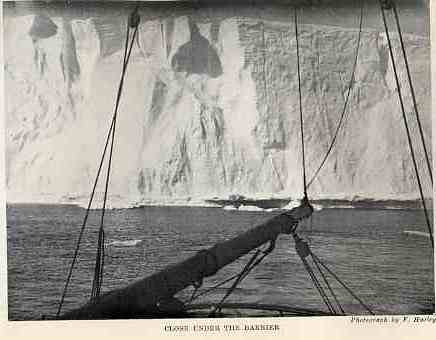
The Endurance lay under the lee of the stranded berg until 7 a.m. on January 18. The gale had moderated by that time, and we proceeded under sail to the south-west through a lane that had opened along the glacier-front. We skirted the glacier till 9.30 a.m., when it ended in two bays, open to the north-west but sheltered by stranded bergs to the west. The coast beyond trended south-south-west with a gentle land-slope.
The Endurance sheltered behind the stranded iceberg until 7 a.m. on January 18. By then, the gale had weakened. We sailed southwest through a channel that had opened along the glacier front. We followed the edge of the glacier until 9.30 a.m., when it ended in two bays. The bays were open to the northwest but sheltered to the west by stranded icebergs. Beyond them, the coast ran south-southwest, with the land rising gently.
“The pack now forces us to go west 14 miles, when we break through a long line of heavy brash mixed with large lumps and ‘growlers.’ We do this under the fore-topsail only, the engines being stopped to protect the propeller. This takes us into open water, where we make S. 50° W. for 24 miles. Then we again encounter pack which forces us to the north-west for 10 miles, when we are brought up by heavy snow-lumps, brash, and large, loose floes. The character of the pack shows change. The floes are very thick and are covered by deep snow. The brash between the floes is so thick and heavy that we cannot push through without a great expenditure of power, and then for a short distance only. We therefore lie to for a while to see if the pack opens at all when this north-east wind ceases.”
“The pack ice now forces us 14 miles west. There we break through a long line of heavy brash ice mixed with large lumps and ‘growlers.’ We use only the fore-topsail, keeping the engines stopped to protect the propeller. This brings us into open water, where we travel 24 miles on a bearing of S. 50° W. Then we encounter pack ice again, which forces us 10 miles northwest. There, heavy snow-lumps, brash ice, and large, loose floes bring us to a stop. The pack ice has changed. The floes are very thick and covered in deep snow. The brash ice between them is so thick and heavy that we can push through only a short distance. Even then, doing so takes a great deal of power. So we stop for a while to see if the pack ice opens at all when the northeast wind dies down.”
Our position on the morning of the 19th was lat. 76° 34´ S., long. 31° 30´ W. The weather was good, but no advance could be made. The ice had closed around the ship during the night, and no water could be seen in any direction from the deck. A few lanes were in sight from the mast-head. We sounded in 312 fathoms, finding mud, sand, and pebbles. The land showed faintly to the east. We waited for the conditions to improve, and the scientists took the opportunity to dredge for biological and geological specimens. During the night a moderate north-easterly gale sprang up, and a survey of the position on the 20th showed that the ship was firmly beset. The ice was packed heavily and firmly all round the Endurance in every direction as far as the eye could reach from the masthead. There was nothing to be done till the conditions changed, and we waited through that day and the succeeding days with increasing anxiety. The east-north-easterly gale that had forced us to take shelter behind the stranded berg on the 16th had veered later to the north-east, and it continued with varying intensity until the 22nd. Apparently this wind had crowded the ice into the bight of the Weddell Sea, and the ship was now drifting south-west with the floes which had enclosed it. A slight movement of the ice round the ship caused the rudder to become dangerously jammed on the 21st, and we had to cut away the ice with ice-chisels, heavy pieces of iron with 6-ft. wooden hafts. We kept steam up in readiness for a move if the opportunity offered, and the engines running full speed ahead helped to clear the rudder. Land was in sight to the east and south about sixteen miles distant on the 22nd. The land-ice seemed to be faced with ice-cliffs at most points, but here and there slopes ran down to sea-level. Large crevassed areas in terraces parallel with the coast showed where the ice was moving down over foot-hills. The inland ice appeared for the most part to be undulating, smooth, and easy to march over, but many crevasses might have been concealed from us by the surface snow or by the absence of shadows. I thought that the land probably rose to a height of 5000 ft. forty or fifty miles inland. The accurate estimation of heights and distances in the Antarctic is always difficult, owing to the clear air, the confusing monotony of colouring, and the deceptive effect of mirage and refraction. The land appeared to increase in height to the southward, where we saw a line of land or barrier that must have been seventy miles, and possibly was even more distant.
On the morning of the 19th, our position was latitude 76° 34´ S., longitude 31° 30´ W. The weather was good, but we could make no progress. The ice had closed around the ship during the night, and no water could be seen from the deck. From the masthead, a few lanes of open water were visible. We measured the depth at 312 fathoms and found mud, sand, and pebbles on the bottom. The land was faintly visible to the east. We waited for conditions to improve, and the scientists took the opportunity to dredge for biological and geological specimens. During the night, a moderate northeasterly gale sprang up. When we surveyed our position on the 20th, the ship was firmly trapped. The ice was tightly packed around the Endurance in every direction, as far as the eye could see from the masthead. There was nothing to do until conditions changed. We waited through that day and the days that followed with growing anxiety. The east-northeasterly gale had forced us to shelter behind the stranded iceberg on the 16th. Later, it had shifted to the northeast and continued with varying intensity until the 22nd. The wind had apparently crowded the ice into the curve of the Weddell Sea. The ship was now drifting southwest with the ice floes that enclosed it. On the 21st, a slight movement of the ice around the ship caused the rudder to become dangerously jammed. We had to cut away the ice with ice chisels. These were heavy pieces of iron with six-foot wooden handles. We kept steam up, ready to move if the opportunity arose. Running the engines at full speed ahead helped to clear the rudder. On the 22nd, land was visible to the east and south, about sixteen miles away. The ice covering the land seemed to form cliffs at most points, but here and there slopes ran down to sea level. Large, crevassed areas formed terraces parallel to the coast. These showed where the ice was moving down over the foothills. Most of the inland ice appeared gently rolling, smooth, and easy to march over. But surface snow or a lack of shadows might have hidden many crevasses from us. I thought the land probably rose to 5,000 feet, forty or fifty miles inland. In Antarctica, it is always difficult to judge heights and distances accurately. The air is clear, the colors are confusingly monotonous, and mirages and refraction can be deceptive. The land appeared to rise farther south. There we saw a line of land or an ice barrier that must have been seventy miles away, and possibly even farther.
Sunday, January 24, was a clear sunny day, with gentle easterly and southerly breezes. No open water could be seen from the mast-head, but there was a slight water-sky to the west and north-west. “This is the first time for ten days that the wind has varied from north-east and east, and on five of these days it has risen to a gale. Evidently the ice has become firmly packed in this quarter, and we must wait patiently till a southerly gale occurs or currents open the ice. We are drifting slowly. The position to-day was 76° 49´ S., 33° 51´ W. Worsley and James, working on the floe with a Kew magnetometer, found the variation to be six degrees west.” Just before midnight a crack developed in the ice five yards wide and a mile long, fifty yards ahead of the ship. The crack had widened to a quarter of a mile by 10 a.m. on the 25th, and for three hours we tried to force the ship into this opening with engines at full speed ahead and all sails set. The sole effect was to wash some ice away astern and clear the rudder, and after convincing myself that the ship was firmly held I abandoned the attempt. Later in the day Crean and two other men were over the side on a stage chipping at a large piece of ice that had got under the ship and appeared to be impeding her movement. The ice broke away suddenly, shot upward and overturned, pinning Crean between the stage and the haft of the heavy 11-ft. iron pincher. He was in danger for a few moments, but we got him clear, suffering merely from a few bad bruises. The thick iron bar had been bent against him to an angle of 45 degrees.
Sunday, January 24, was clear and sunny, with gentle breezes from the east and south. No open water could be seen from the masthead. But a slight water-sky, a sign of open water, appeared to the west and northwest. “This is the first time in ten days that the wind has shifted from the northeast and east. On five of those days, it has risen to a gale. Clearly, the ice has become tightly packed in this area. We must wait patiently for a southerly gale or for currents to open the ice. We are drifting slowly. Today’s position was 76° 49´ S., 33° 51´ W. Worsley and James worked on the floe with a Kew magnetometer. They found that the magnetic variation was six degrees west.” Just before midnight, a crack appeared in the ice fifty yards ahead of the ship. It was five yards wide and a mile long. By 10 a.m. on the 25th, the crack had widened to a quarter of a mile. For three hours, we tried to force the ship into the opening. We ran the engines at full speed ahead and set all the sails. But all we achieved was to wash some ice away behind the ship and clear the rudder. Once I was sure the ship was firmly held, I gave up the attempt. Later that day, Crean and two other men were on a stage over the ship’s side. They were chipping at a large piece of ice that had slipped beneath the ship. The ice appeared to be blocking her movement. It suddenly broke away, shot upward, and overturned. It pinned Crean between the stage and the shaft of the heavy, 11-foot iron pincher. He was in danger for a few moments, but we got him free. He had suffered only a few bad bruises. The thick iron bar had been bent against him at an angle of 45 degrees.
The days that followed were uneventful. Moderate breezes from the east and south-west had no apparent effect upon the ice, and the ship remained firmly held. On the 27th, the tenth day of inactivity, I decided to let the fires out. We had been burning half a ton of coal a day to keep steam in the boilers, and as the bunkers now contained only 67 tons, representing thirty-three days’ steaming, we could not afford to continue this expenditure of fuel. Land still showed to the east and south when the horizon was clear. The biologist was securing some interesting specimens with the hand-dredge at various depths. A sounding on the 26th gave 360 fathoms, and another on the 29th 449 fathoms. The drift was to the west, and an observation on the 31st (Sunday) showed that the ship had made eight miles during the week. James and Hudson rigged the wireless in the hope of hearing the monthly message from the Falkland Islands. This message would be due about 3.20 a.m. on the following morning, but James was doubtful about hearing anything with our small apparatus at a distance of 1630 miles from the dispatching station. We heard nothing, as a matter of fact, and later efforts were similarly unsuccessful. The conditions would have been difficult even for a station of high power.
The days that followed were uneventful. Moderate breezes from the east and southwest had no apparent effect on the ice, and the ship remained firmly trapped. On the 27th, the tenth day without progress, I decided to put out the fires. We had been burning half a ton of coal a day to keep steam in the boilers. Only 67 tons remained in the bunkers, enough for thirty-three days under steam, so we could not afford to keep burning fuel at that rate. Land was still visible to the east and south when the horizon was clear. The biologist was collecting some interesting specimens from various depths with the hand-dredge. A depth measurement on the 26th gave 360 fathoms, and another on the 29th gave 449 fathoms. We were drifting west, and an observation on the 31st, a Sunday, showed that the ship had traveled eight miles during the week. James and Hudson set up the wireless, hoping to hear the monthly message from the Falkland Islands. The message was due at about 3.20 a.m. the next morning. But James doubted that our small apparatus could receive anything from the transmitting station, 1630 miles away. In fact, we heard nothing, and later attempts were also unsuccessful. The conditions would have been difficult even for a high-powered station.
We were accumulating gradually a stock of seal meat during these days of waiting. Fresh meat for the dogs was needed, and seal-steaks and liver made a very welcome change from the ship’s rations aboard the Endurance. Four crab-eaters and three Weddells, over a ton of meat for dog and man, fell to our guns on February 2, and all hands were occupied most of the day getting the carcasses back to the ship over the rough ice. We rigged three sledges for man-haulage and brought the seals about two miles, the sledging parties being guided among the ridges and pools by semaphore from the crow’s-nest. Two more seals were sighted on the far side of a big pool, but I did not allow them to be pursued. Some of the ice was in a treacherous condition, with thin films hiding cracks and pools, and I did not wish to risk an accident.
During these days of waiting, we gradually built up a stock of seal meat. The dogs needed fresh meat, and seal steaks and liver were a welcome change from the ship’s rations aboard the Endurance. On February 2, we shot four crabeater seals and three Weddell seals, providing over a ton of meat for dogs and men. All hands spent most of the day bringing the carcasses back to the ship over the rough ice. We prepared three sledges for the men to pull and brought the seals about two miles. From the crow’s-nest, a man used semaphore signals to guide the sledging parties among the ridges and pools. We sighted two more seals on the far side of a large pool, but I did not allow anyone to pursue them. Some of the ice was treacherous, with thin films of ice hiding cracks and pools, and I did not want to risk an accident.
A crack about four miles long opened in the floe to the stern of the ship on the 3rd. The narrow lane in front was still open, but the prevailing light breezes did not seem likely to produce any useful movement in the ice. Early on the morning of the 5th a north-easterly gale sprang up, bringing overcast skies and thick snow. Soon the pack was opening and closing without much loosening effect. At noon the ship gave a sudden start and heeled over three degrees. Immediately afterwards a crack ran from the bows to the lead ahead and another to the lead astern. I thought it might be possible to reeve the ship through one of these leads towards open water, but we could see no water through the thick snow; and before steam was raised, and while the view was still obscured, the pack closed again. The northerly gale had given place to light westerly breezes on the 6th. The pack seemed to be more solid than ever. It stretched almost unbroken to the horizon in every direction, and the situation was made worse by very low temperatures in succeeding days. The temperature was down to zero on the night of the 7th and was two degrees below zero on the 8th. This cold spell in midsummer was most unfortunate from our point of view, since it cemented the pack and tightened the grip of the ice upon the ship. The slow drift to the south-west continued, and we caught occasional glimpses of distant uplands on the eastern horizon. The position on the 7th was lat. 76° 57´ S., long. 35° 7´ W. Soundings on the 6th and 8th found glacial mud at 630 and 529 fathoms.
On the 3rd, a crack about four miles long opened in the ice floe behind the ship. The narrow channel ahead was still open, but the light prevailing breezes seemed unlikely to move the ice much. Early on the morning of the 5th, a gale sprang up from the northeast, bringing overcast skies and heavy snow. Soon the pack ice began to open and close, but it did not loosen much. At noon, the ship lurched suddenly and tilted three degrees. Immediately afterward, a crack ran from the bow to the channel ahead. Another ran to the channel behind us. I thought we might be able to work the ship through one of these channels toward open water. But the thick snow prevented us from seeing any water. Before we could raise steam, and while the view was still blocked, the pack closed again. By the 6th, the northerly gale had given way to light westerly breezes. The pack seemed more solid than ever. It stretched almost unbroken to the horizon in every direction. Very low temperatures in the following days made the situation worse. The temperature fell to zero on the night of the 7th and to two degrees below zero on the 8th. This cold spell in midsummer was most unfortunate for us. It cemented the pack together and tightened the ice's grip on the ship. We continued to drift slowly southwest and occasionally caught glimpses of distant high ground on the eastern horizon. On the 7th, our position was latitude 76° 57´ S., longitude 35° 7´ W. Soundings on the 6th and 8th found glacial mud at depths of 630 and 529 fathoms.
The Endurance was lying in a pool covered by young ice on the 9th. The solid floes had loosened their grip on the ship itself, but they were packed tightly all around. The weather was foggy. We felt a slight northerly swell coming through the pack, and the movement gave rise to hope that there was open water near to us. At 11 a.m. a long crack developed in the pack, running east and west as far as we could see through the fog, and I ordered steam to be raised in the hope of being able to break away into this lead. The effort failed. We could break the young ice in the pool, but the pack defied us. The attempt was renewed on the 11th, a fine clear day with blue sky. The temperature was still low, –2° Fahr. at midnight. After breaking through some young ice the Endurance became jammed against soft floe. The engines running full speed astern produced no effect until all hands joined in “sallying” ship. The dog-kennels amidships made it necessary for the people to gather aft, where they rushed from side to side in a mass in the confined space around the wheel. This was a ludicrous affair, the men falling over one another amid shouts of laughter without producing much effect on the ship. She remained fast, while all hands jumped at the word of command, but finally slid off when the men were stamping hard at the double. We were now in a position to take advantage of any opening that might appear. The ice was firm around us, and as there seemed small chance of making a move that day, I had the motor crawler and warper put out on the floe for a trial run. The motor worked most successfully, running at about six miles an hour over slabs and ridges of ice hidden by a foot or two of soft snow. The surface was worse than we would expect to face on land or barrier-ice. The motor warped itself back on a 500-fathom steel wire and was taken aboard again. “From the mast-head the mirage is continually giving us false alarms. Everything wears an aspect of unreality. Icebergs hang upside down in the sky; the land appears as layers of silvery or golden cloud. Cloud-banks look like land, icebergs masquerade as islands or nunataks, and the distant barrier to the south is thrown into view, although it really is outside our range of vision. Worst of all is the deceptive appearance of open water, caused by the refraction of distant water, or by the sun shining at an angle on a field of smooth snow or the face of ice-cliffs below the horizon.”
On the 9th, the Endurance lay in a pool covered with young ice. The solid floes had loosened their grip on the ship, but they were packed tightly all around her. The weather was foggy. We felt a slight northerly swell passing through the pack ice. This movement gave us hope that open water was nearby. At 11 a.m., a long crack appeared in the pack. It ran east and west as far as we could see through the fog. I ordered steam to be raised, hoping we could break free into this lead. The effort failed. We could break the young ice in the pool, but we could not break through the pack. We tried again on the 11th, a fine, clear day with a blue sky. The temperature was still low, at −2° Fahrenheit at midnight. After breaking through some young ice, the Endurance became jammed against a soft floe. The engines ran at full speed in reverse, but had no effect until all hands joined in “sallying” the ship. The dog kennels amidships forced the men to gather aft. There, in the confined space around the wheel, they rushed from side to side together. It was a ridiculous sight. The men fell over one another amid shouts of laughter, without having much effect on the ship. She remained stuck while all hands jumped on command. But she finally slid free when the men were stamping hard and fast. We were now in a position to take advantage of any opening that might appear. The ice was firm around us, and there seemed little chance of moving that day. So I had the motor crawler and warper put out on the floe for a trial run. The motor worked very well. It ran at about six miles an hour over slabs and ridges of ice hidden by a foot or two of soft snow. The surface was worse than we would expect to face on land or barrier ice. The motor pulled itself back using a 500-fathom steel wire and was taken aboard again. “From the masthead, the mirage is continually giving us false alarms. Everything looks unreal. Icebergs hang upside down in the sky. The land looks like layers of silver or gold cloud. Cloud banks look like land, and icebergs pretend to be islands or nunataks. The distant barrier to the south comes into view, although it is really beyond our range of vision. Worst of all is the false appearance of open water. This is caused by the refraction of distant water, or by the sun shining at an angle on a field of smooth snow or on the face of ice cliffs below the horizon.”
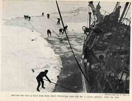
The second half of February produced no important change in our situation. Early in the morning of the 14th I ordered a good head of steam on the engines and sent all hands on to the floe with ice-chisels, prickers, saws, and picks. We worked all day and throughout most of the next day in a strenuous effort to get the ship into the lead ahead. The men cut away the young ice before the bows and pulled it aside with great energy. After twenty-four hours’ labour we had got the ship a third of the way to the lead. But about 400 yards of heavy ice, including old rafted pack, still separated the Endurance from the water, and reluctantly I had to admit that further effort was useless. Every opening we made froze up again quickly owing to the unseasonably low temperature. The young ice was elastic and prevented the ship delivering a strong, splitting blow to the floe, while at the same time it held the older ice against any movement. The abandonment of the attack was a great disappointment to all hands. The men had worked long hours without thought of rest, and they deserved success. But the task was beyond our powers. I had not abandoned hope of getting clear, but was counting now on the possibility of having to spend a winter in the inhospitable arms of the pack. The sun, which had been above the horizon for two months, set at midnight on the 17th, and, although it would not disappear until April, its slanting rays warned us of the approach of winter. Pools and leads appeared occasionally, but they froze over very quickly.
The second half of February brought no major change in our situation. Early on the morning of the 14th, I ordered the engines brought up to full steam. I sent all hands onto the floe with ice chisels, prickers, saws, and picks. We worked all day and most of the next day, trying hard to get the ship into the open channel ahead. The men energetically cut away the young ice in front of the bows and pulled it aside. After twenty-four hours of work, we had moved the ship a third of the way to the channel. But about 400 yards of heavy ice still separated the Endurance from the water. This included old pack ice piled in overlapping layers. Reluctantly, I had to admit that further effort was useless. Every opening we made froze over again quickly because of the unusually low temperature. The young ice was elastic and kept the ship from striking the floe hard enough to split it. At the same time, the young ice held the older ice in place. Giving up the attempt was a great disappointment to all hands. The men had worked long hours without thought of rest, and they deserved success. But the task was beyond our powers. I had not given up hope of getting clear. Still, I was now considering the possibility that we would have to spend a winter in the inhospitable arms of the pack. The sun had been above the horizon for two months. It set at midnight on the 17th, and its slanting rays warned us that winter was approaching. Yet the sun would not disappear until April. Pools and open channels appeared occasionally, but they froze over very quickly.
We continued to accumulate a supply of seal meat and blubber, and the excursions across the floes to shoot and bring in the seals provided welcome exercise for all hands. Three crab-eater cows shot on the 21st were not accompanied by a bull, and blood was to be seen about the hole from which they had crawled. We surmised that the bull had become the prey of one of the killer-whales. These aggressive creatures were to be seen often in the lanes and pools, and we were always distrustful of their ability or willingness to discriminate between seal and man. A lizard-like head would show while the killer gazed along the floe with wicked eyes. Then the brute would dive, to come up a few moments later, perhaps, under some unfortunate seal reposing on the ice. Worsley examined a spot where a killer had smashed a hole 8 ft. by 12 ft. in 12½ in. of hard ice, covered by 2½ in. of snow. Big blocks of ice had been tossed on to the floe surface. Wordie, engaged in measuring the thickness of young ice, went through to his waist one day just as a killer rose to blow in the adjacent lead. His companions pulled him out hurriedly.
We continued to build up a supply of seal meat and blubber. Trips across the ice floes to shoot and bring back seals provided welcome exercise for everyone. Three female crabeater seals shot on the 21st had no male with them. Blood was visible around the hole from which they had crawled. We guessed that the male had fallen prey to a killer whale. We often saw these aggressive creatures in the channels and pools. We were always wary of whether they could or would distinguish between a seal and a man. A lizard-like head would appear, and the killer whale would gaze along the floe with wicked eyes. Then the brute would dive. Perhaps a few moments later it would come up beneath some unfortunate seal resting on the ice. Worsley examined a spot where a killer whale had smashed an 8-by-12-foot hole through 12½ inches of hard ice. The ice was covered by 2½ inches of snow. Large blocks of ice had been tossed onto the surface of the floe. One day, Wordie was measuring the thickness of young ice when he fell through up to his waist. Just then, a killer whale rose to blow in the nearby channel. His companions hurriedly pulled him out.
On the 22nd the Endurance reached the farthest south point of her drift, touching the 77th parallel of latitude in long. 35° W. The summer had gone; indeed the summer had scarcely been with us at all. The temperatures were low day and night, and the pack was freezing solidly around the ship. The thermometer recorded 10° below zero Fahr. at 2 a.m. on the 22nd. Some hours earlier we had watched a wonderful golden mist to the southward, where the rays of the declining sun shone through vapour rising from the ice. All normal standards of perspective vanish under such conditions, and the low ridges of the pack, with mist lying between them, gave the illusion of a wilderness of mountain-peaks like the Bernese Oberland. I could not doubt now that the Endurance was confined for the winter. Gentle breezes from the east, south, and south-west did not disturb the hardening floes. The seals were disappearing and the birds were leaving us. The land showed still in fair weather on the distant horizon, but it was beyond our reach now, and regrets for havens that lay behind us were vain.
On the 22nd, the Endurance reached the farthest south point of her drift, at 77° south latitude and 35° west longitude. Summer had gone. In fact, we had hardly had a summer at all. Temperatures were low day and night, and the pack ice was freezing solid around the ship. At 2 a.m. on the 22nd, the thermometer recorded 10° below zero Fahrenheit. Some hours earlier, we had watched a wonderful golden mist to the south. There, the rays of the setting sun shone through vapor rising from the ice. Under such conditions, all normal sense of perspective disappears. Mist lay between the low ridges of the pack ice, making them look like a wilderness of mountain peaks, like those of the Bernese Oberland. I could no longer doubt that the Endurance was trapped for the winter. Gentle breezes from the east, south, and south-west did not disturb the hardening ice floes. The seals were disappearing, and the birds were leaving us. In clear weather, we could still see land on the distant horizon. But it was now beyond our reach, and there was no point in regretting the safe harbors we had left behind.
“We must wait for the spring, which may bring us better fortune. If I had guessed a month ago that the ice would grip us here, I would have established our base at one of the landing-places at the great glacier. But there seemed no reason to anticipate then that the fates would prove unkind. This calm weather with intense cold in a summer month is surely exceptional. My chief anxiety is the drift. Where will the vagrant winds and currents carry the ship during the long winter months that are ahead of us? We will go west, no doubt, but how far? And will it be possible to break out of the pack early in the spring and reach Vahsel Bay or some other suitable landing-place? These are momentous questions for us.”
“We must wait for spring, which may bring us better luck. If I had guessed a month ago that the ice would trap us here, I would have established our base at one of the landing places at the great glacier. But at the time, there seemed no reason to expect fate to turn against us. This calm weather and intense cold in a summer month must surely be unusual. My main worry is the drift. Where will the shifting winds and currents carry the ship during the long winter months ahead? We will go west, no doubt, but how far? And will we be able to break out of the pack ice early in spring and reach Vahsel Bay or another suitable landing place? These are crucial questions for us.”
On February 24 we ceased to observe ship routine, and the Endurance became a winter station. All hands were on duty during the day and slept at night, except a watchman who looked after the dogs and watched for any sign of movement in the ice. We cleared a space of 10 ft. by 20 ft. round the rudder and propeller, sawing through ice 2 ft. thick, and lifting the blocks with a pair of tongs made by the carpenter. Crean used the blocks to make an ice-house for the dog Sally, which had added a little litter of pups to the strength of the expedition. Seals appeared occasionally, and we killed all that came within our reach. They represented fuel as well as food for men and dogs. Orders were given for the after-hold to be cleared and the stores checked, so that we might know exactly how we stood for a siege by an Antarctic winter. The dogs went off the ship on the following day. Their kennels were placed on the floe along the length of a wire rope to which the leashes were fastened. The dogs seemed heartily glad to leave the ship, and yelped loudly and joyously as they were moved to their new quarters. We had begun the training of teams, and already there was keen rivalry between the drivers. The flat floes and frozen leads in the neighbourhood of the ship made excellent training grounds. Hockey and football on the floe were our chief recreations, and all hands joined in many a strenuous game.
On February 24, we stopped following the ship’s routine, and the Endurance became a winter station. Everyone worked during the day and slept at night, except for one watchman. He looked after the dogs and watched for any sign of movement in the ice. We cleared a space 10 feet by 20 feet around the rudder and propeller. We sawed through ice 2 feet thick and lifted the blocks with tongs made by the carpenter. Crean used the blocks to build an ice house for Sally, who had added a little litter of pups to the expedition. Seals appeared occasionally, and we killed all that came within reach. They provided fuel as well as food for the men and dogs. Orders were given to clear the after-hold and check the stores. This would tell us exactly what supplies we had for a siege by an Antarctic winter. The dogs left the ship the next day. Their kennels were placed on the floe along a wire rope, and their leashes were fastened to it. The dogs seemed very glad to leave the ship. They yelped loudly and joyfully as they were moved to their new quarters. We had begun training the teams, and the drivers were already keen rivals. The flat floes and frozen channels near the ship made excellent training grounds. Hockey and football on the floe were our main forms of recreation, and everyone joined in many a strenuous game.
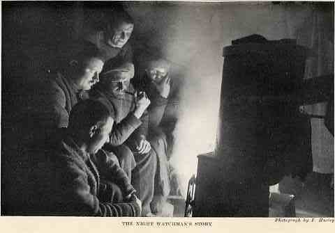
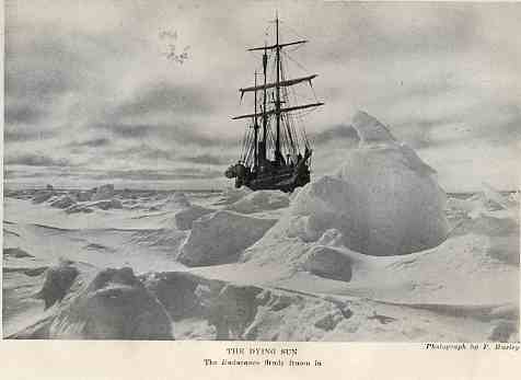
Worsley took a party to the floe on the 26th and started building a line of igloos and “dogloos” round the ship. These little buildings were constructed, Esquimaux fashion, of big blocks of ice, with thin sheets for the roofs. Boards or frozen sealskins were placed over all, snow was piled on top and pressed into the joints, and then water was thrown over the structures to make everything firm. The ice was packed down flat inside and covered with snow for the dogs, which preferred, however, to sleep outside except when the weather was extraordinarily severe. The tethering of the dogs was a simple matter. The end of a chain was buried about eight inches in the snow, some fragments of ice were pressed around it, and a little water poured over all. The icy breath of the Antarctic cemented it in a few moments. Four dogs which had been ailing were shot. Some of the dogs were suffering badly from worms, and the remedies at our disposal, unfortunately, were not effective. All the fit dogs were being exercised in the sledges, and they took to the work with enthusiasm. Sometimes their eagerness to be off and away produced laughable results, but the drivers learned to be alert. The wireless apparatus was still rigged, but we listened in vain for the Saturday-night time signals from New Year Island, ordered for our benefit by the Argentine Government. On Sunday the 28th, Hudson waited at 2 a.m. for the Port Stanley monthly signals, but could hear nothing. Evidently the distances were too great for our small plant.
On the 26th, Worsley took a party onto the ice floe. They began building a line of igloos and “dogloos” around the ship. The small shelters were built in the Inuit style, using large blocks of ice and thin sheets of ice for roofs. Boards or frozen sealskins were laid over them, and snow was piled on top and pressed into the joints. Then water was thrown over the shelters to make everything firm. Inside, the ice was packed flat and covered with snow for the dogs. The dogs, however, preferred to sleep outside except in extraordinarily severe weather. Tethering the dogs was simple. The end of a chain was buried about eight inches deep in the snow. Fragments of ice were pressed around it, and a little water was poured over everything. The icy breath of the Antarctic cemented the chain in place within moments. Four dogs that had been ill were shot. Some of the dogs were suffering badly from worms, and unfortunately, the remedies we had were not effective. All the fit dogs were being exercised with the sledges, and they took to the work with enthusiasm. Sometimes their eagerness to get away produced comical results, but the drivers learned to stay alert. The wireless equipment was still set up, but we listened in vain for the Saturday night time signals from New Year Island. The Argentine Government had arranged for the signals to be sent for our benefit. On Sunday the 28th, Hudson waited at 2 a.m. for the monthly signals from Port Stanley, but he could hear nothing. Evidently, the distances were too great for our small wireless set.